Your unfair advantage on gold country.
Snap a photo of a creek. Lodeline pulls pro-grade USGS LiDAR terrain for that exact spot, scores it 0–100 for gold favorability, and its AI geologist names the real mines nearby and reads the ground like a pro. Pay once, own the app forever.
Real USGS terrain science. No gimmicky gold-detector promises.
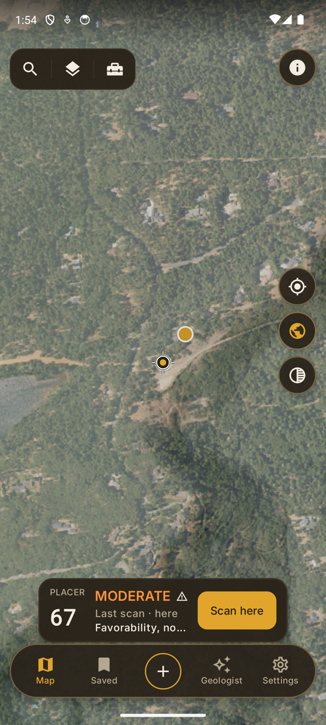
- Built on USGS 3DEP LiDAR — no API key
- Pay once for Pro — own the app forever
- Works offline — map packs for the field
- US-wide — anywhere USGS LiDAR reaches
- Starts from a photo — snap it → terrain + score
Photo in. Game plan out.
From a snapshot to a scored spot with a briefing — before you burn a tank of gas.
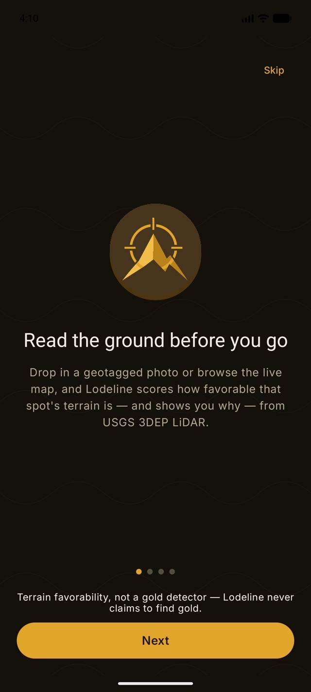
Point at a spot
Open a photo you took in the field — Lodeline uses the location saved in it — or pan the live LiDAR map to any creek, bench, hillside, or bend in the US.
Get a favorability read
Lodeline scores the landform 0–100 (LOW / MODERATE / HIGH) and breaks down the reasons — drainage, slope, benches, landscape position.
Scout smarter
Save the spot, ask the AI geologist why it scored that way, group it into a trip, then verify the land status before you dig.
A full prospecting arsenal in your pocket.
Pan, sluice, highbank, dredge, detect, dig, or chase hardrock — pro-grade tools for reading the land.
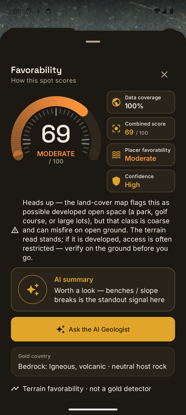
A score you can actually reason about.
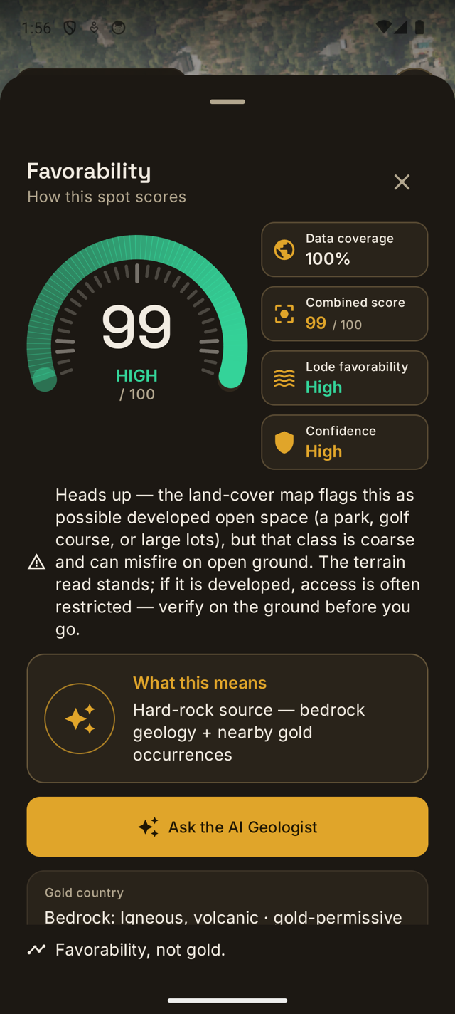
Every spot gets a favorability score from 0 to 100 — how good the ground looks for gold, shown as LOW, MODERATE, or HIGH — computed on your device from public USGS elevation data. But the number is only half of it. Swipe up and Lodeline shows you the factors it weighed: how strongly water collects and concentrates gold, whether the slope is favorable, and where benches and breaks-in-slope sit relative to the landscape. It reads like a field note, not a black box.
- Legible factors, not magic — water collection & drainage, favorable slope, benches & breaks-in-slope, low landscape position, each with its own bar.
- Ask the AI geologist Plus — tap the button right on the sheet for a grounded field briefing of what the terrain is doing and what to look at on the ground.
- A high score means the shape of the land resembles classic gold-bearing ground — nothing more.
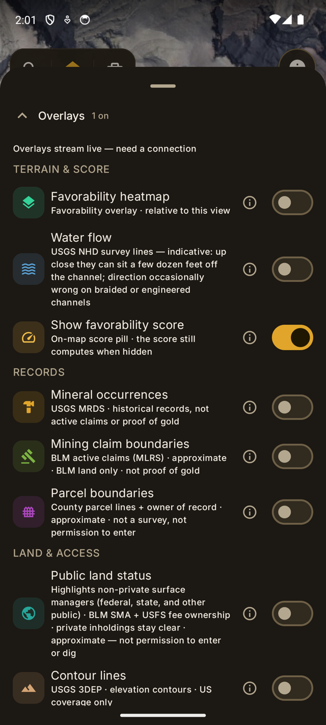
See the shape of the land — like X-ray vision for the ground.
Switch between crisp satellite imagery and USGS LiDAR hillshade to see slope, benches, and old channels the naked eye misses. Every render type USGS publishes is free — pick one, dial the opacity, and layer the favorability heatmap on top to read a whole drainage at a glance. Pro unlocks Lodeline Relief, our own hillshade tuned for prospecting. It's the premium terrain view other apps lock behind their most expensive tier, built on the same free government data.
- Satellite + LiDAR hillshade basemaps, with adjustable terrain opacity.
- Lodeline Relief Pro — a proprietary hillshade tuned to show benches, old channels, and slope breaks.
- Favorability heatmap — favorability across the view you're looking at, relative to that view.
- Mineral occurrences overlay Pro — USGS MRDS records, framed honestly: historical records, not active claims or proof of gold.
Historical records — not active claims, and not proof of gold. Always verify land status.
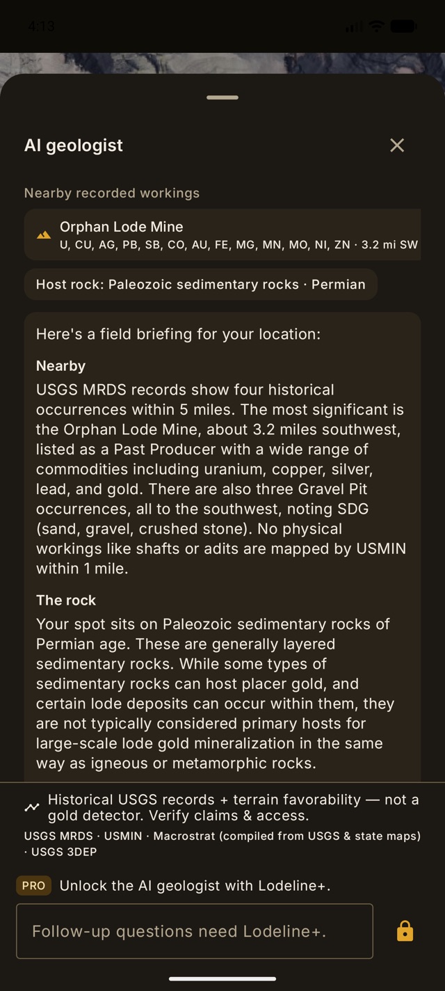
A geologist in your pocket — for any spot on the map.
PlusTap Ask the AI geologist on any spot and get a real field briefing, not a canned blurb: it names the actual historical mines around your point from real USGS records — with distance and bearing — tells you the host rock under your feet, and reads the drainages, slope breaks, and bench gravels like a seasoned pro. Then ask your follow-up questions. Planning a whole day out? The AI trip planner strings your best spots into a sensible route. Your first three briefings are free — try it on your favorite creek. That screenshot? A real, unedited briefing.
- Grounded briefings — named nearby mines (distance + bearing), host rock, and terrain reasoning from public USGS records.
- Photo reads — show the geologist a photo of the bank, the gravel, or your pan and it tells you what it sees.
- AI trip planner — turn your saved spots into an ordered scouting route.
- AI area intel — one tap analyzes the whole view and returns ranked spots, each with a short grounded "why".
- AI-structured dig log — jot a rough field note and the AI cleans it into a tidy entry.
Placer or lode — pick your hunt.
One toggle switches the whole scoring model. Placer reads stream gold the classic way — terrain traps (drainage, slope, benches) fused with bedrock geology. Lode goes hard-rock: gold-permissive bedrock, USGS gold districts, and the density of historical gold occurrences around your point. Same honest 0–100 scale, same "show your work" breakdown — tuned to how you actually prospect.
- Two-axis score — "Gold country" (regional geology) × "Spot" (the trap at your exact point), so you always see why.
- Best reaches near you — ranks the real mapped stream channels around you and pins the top ones A, B, C on the map.
Everything you scout, saved and ready — even off the grid.
Save spots as waypoints and record GPS tracks as you walk the ground. Download offline map packs before you lose signal so the terrain, the score, and your saved spots all keep working deep in the canyon. BLM land-status and mining-claims overlays are free for everyone; Pro adds the USGS MRDS mineral-occurrence layer and county parcel boundaries so you can do your homework before you set out.
- Waypoints & GPS track recording — your scouting log, on your phone. Trips & the dig log Pro group the day and record what you actually panned.
- Offline map packs Pro — LiDAR + satellite tiles cached for no-signal country.
- BLM land-status & claims overlays (free) + MRDS mineral occurrences Pro — research where you can legally look.
- Parcel boundaries & owner of record Pro — county parcel lines in MT, NC, WA, CO & VA statewide plus gold-district counties in CA, OR, ID, AZ, NV, GA & SC, with the owner where counties publish it. Approximate GIS lines — never permission to enter.
And the rest of the kit.
- Elevation & slope transect Pro — drag a line, or drop Measure points and open an elevation profile from the same tool.
- Downstream catch-finder Pro/Plus — traces where runoff is likely to drop material below your pin, with honest catch-geometry scores (never mixed into favorability).
- Ground disturbance (beta) Pro/Plus — scans nearby 1 m LiDAR for surface scars and pits worth a closer look — observations only, never "dig here."
- Track backtrack — while you walk a track, see how far back to the start along the path you already walked.
- Bulk GPX / KML export Pro — send spots, trips, and tracks to any GPS app, or open straight in Google Earth. Single-track export is free.
- River flow & daylight — live USGS gauge flow and sunset time for the day you're planning.
- HD aerial close-ups Pro — USGS NAIP imagery when you zoom in tight.
- Contours & forest roads — USGS contour lines and USFS motor-vehicle roads to plan the walk in.
- Dig log & field finds Pro — record what you actually panned, honest sample by sample; jot a rough note and the Lodeline+ AI writes it up.
- Lat/Lon · UTM · MGRS — tap the readout to cycle formats; long-press to copy. Metric or US units.
- Folders & organization — file spots, trips, tracks, and AI insights your way. An in-app What's-new tracks every update we ship.
Free like a full toolkit. Not a free sample.
Everything below costs $0, forever — no trial clock, no “3 scans left” nag. Our entire business plan is making free so good that one day you buy Pro out of sheer respect.
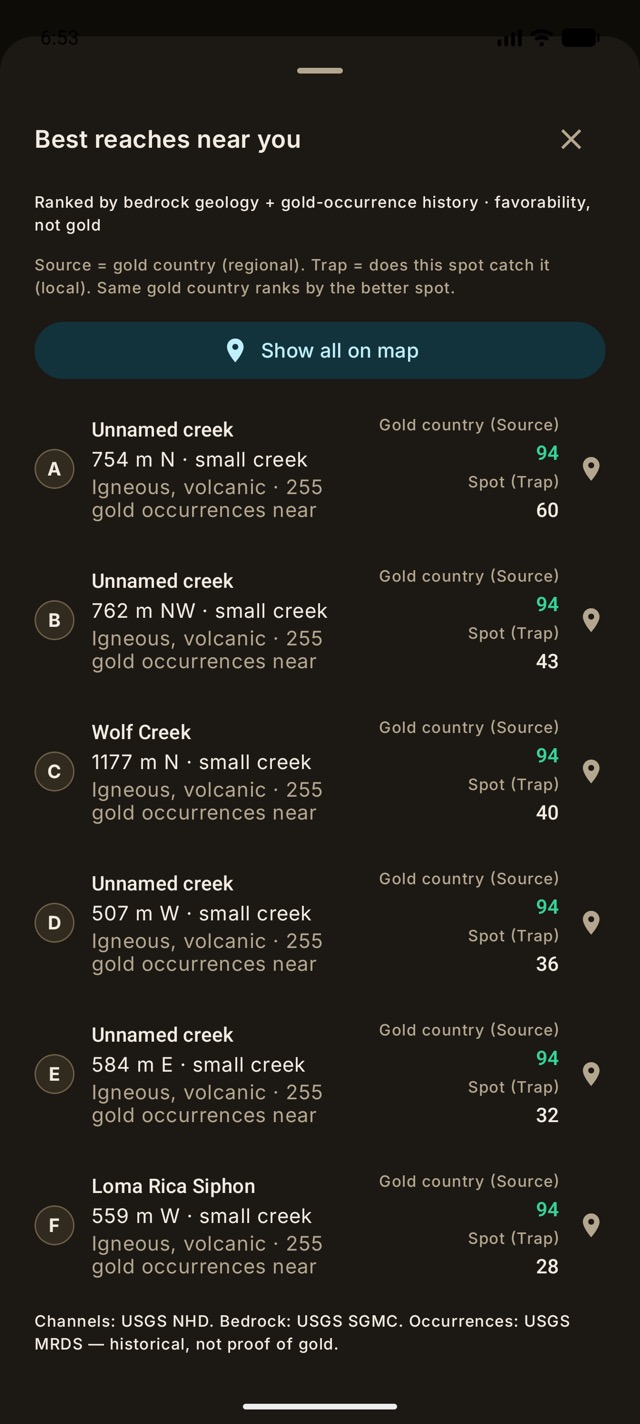
“Where should I walk first?” — try it on us.
Tap one button and Lodeline ranks the real creeks around you — by name, distance, and score — so you start the day at the best reach, not the nearest parking lot. In most apps this is the flagship paid feature. Here, every install gets one full ranked scan free — after that, Best reaches lives in Pro.
- The magic loop — share any geotagged photo and land on that exact ground in LiDAR. Unlimited.
- Full USGS LiDAR terrain — every USGS render type, nothing held back (Lodeline Relief is Pro).
- The favorability score — 0–100 with the full factor breakdown, plus the heatmap overlay.
- Placer and lode modes — stream gold and hard-rock country, both scored.
- A Best-reaches preview — one full ranked scan of the creeks around you, on us.
- Mining-claim boundaries — BLM active-claim lines with links to the official record, because “is this claimed?” should never be a paywall.
- Contours, forest roads & the PLSS grid — plus satellite and hillshade basemaps.
- River flow & daylight — live USGS gauges and sunset time for the day you're planning.
- Track recording & folders — walk the ground and keep your season organized.
- 25 saved spots, photo attachments, Lat/Lon · UTM · MGRS, metric or US units — and your first three AI briefings on us.
Pro ($29.99, once) and Lodeline+ (the AI geologist) exist for the day you catch yourself muttering “I wish I had the federal mine records… offline… on a mountain.” That day comes for everyone. We’ll be ready.
Real science. Straight answers.
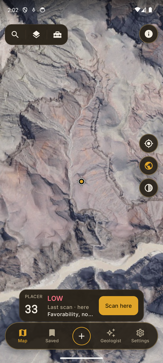
The gimmick apps sell "certainty" and gold-price calculators. Lodeline sells an edge you can verify: the favorability score reads the shape of the land from public USGS LiDAR — how water concentrates gold, where benches and breaks sit — and shows you its work. It scores terrain favorability, not gold, and it will never fake a "gold here" or put a dollar value on anything. That's not hedging — it's the difference between a tool the pros respect and a toy. The proof is in the screenshot: even somewhere as famous as the Grand Canyon, the score reads an honest LOW — and on developed land or open water Lodeline hides the number entirely rather than score a parking lot.
Straight answers keep you sharp in the field — and they're why serious prospectors keep the app.
Stop renting your maps.
USGS LiDAR is public. Paying a yearly bill (often to an overseas company) to rent your own government's elevation data is a bad deal. Lodeline is a one-time purchase: buy it once, own the toolkit forever.
| Feature | Lodeline | Subscription map apps |
|---|---|---|
| Price model | One-time $29.99. Yours forever. | $40–$250 / year, forever |
| LiDAR terrain | Included, free — the whole point | Often a paid add-on, per state |
| Tells you WHY | Readable factors + a grounded AI geologist | A map, or an opaque heatmap |
| Honesty | Real USGS science — no fake "gold here" | "Certainty," gold-price gimmicks |
| Works offline | Yes — downloadable map packs | Sometimes; often thinner offline |
| Data source | Free, keyless USGS 3DEP / MRDS | Same public USGS data, often rented yearly |
| Start from a photo | Yes — a shot from your trip → terrain | No |
| Account required | No account to scout | Account + login |
Lodeline Wins
- Price model
- One-time $29.99. Yours forever.
- LiDAR terrain
- Included, free — the whole point
- Tells you WHY
- Readable factors + a grounded AI geologist
- Honesty
- Real USGS science — no fake "gold here"
- Works offline
- Yes — downloadable map packs
- Data source
- Free, keyless USGS 3DEP / MRDS
- Start from a photo
- Yes — a shot from your trip → terrain
- Account required
- No account to scout
Yearly subscription map apps
- Price model
- $40–$250 / year, forever
- LiDAR terrain
- Often a paid add-on, per state
- Tells you WHY
- A map, or an opaque heatmap
- Honesty
- "Certainty," gold-price gimmicks
- Works offline
- Sometimes; often thinner offline
- Data source
- Same public USGS data, rented yearly
- Start from a photo
- No
- Account required
- Account + login
Over three seasons a subscriber pays again and again for public USGS data. You pay once for Lodeline Pro. Optional AI is the only subscription, and you can skip it.
The "subscription map apps" column describes representative ranges and common practices across the category of mapping and prospecting apps that charge a recurring fee — not any single named product. Prices and features vary by app and change over time.
Start free. Own the tool when you’re ready.
The scouting loop — LiDAR, the score, claim boundaries — is free. Pro is a one-time purchase that unlocks the whole field kit, and Lodeline+ is the only subscription: it keeps the AI engine running.
Free
Not a demo · a working prospecting kit.
- Full USGS LiDAR terrain + every USGS render type
- The favorability score + heatmap — placer and lode
- BLM mining-claim boundaries — safety is never an upsell
- Photo import, track recording, live river flow & daylight
- Up to 25 saved waypoints — plus your first three AI briefings and a Best-reaches preview, free
Lodeline Pro
Own the whole field kit. No renewal, ever.
- Unlimited waypoints + trips & the dig log
- Offline map packs for no-signal country
- Best reaches near you — the creeks around you, ranked, any time
- MRDS mineral occurrences + parcel owner layer — historical mines, and county parcel lines with owner of record (select states)
- Lodeline Relief — proprietary hillshade for benches and old channels
- Water-flow overlay + transect & measure — see where runoff concentrates, cut elevation profiles
- Catch-finder + ground disturbance (beta) — also included with Lodeline+
- HD aerial imagery + bulk GPX/KML export — take it to any GPS app or Google Earth
Lodeline+
The only subscription · it keeps the AI engine running. Cancel anytime.
- AI geologist — grounded briefings + follow-up questions, 25 a day
- Photo reads — show the geologist a photo of the ground, 10 a day
- AI trip planner (5 a day) + area intel (10 a day)
- Downstream catch-finder + ground disturbance (beta)
- AI dig-log notes — a rough field note structured into a clean entry, 20 a day
- Cloud backup — your waypoints, tracks & finds, safe across devices
Lodeline+ is optional and exists because the AI and cloud backup cost us money every month — that's the whole reason it's a subscription. The daily quotas above are the real limits, not fine print, and your first three AI briefings are free for everyone. Cancel anytime — everything you bought keeps working. Pro is a one-time purchase via Google Play: less than three months of a typical subscription app, then yours for life.
Straight answers.
Does Lodeline find gold?
No — and it never claims to. The favorability score rates how good the ground looks for gold, based on the shape of the land in USGS elevation data. A high score means the terrain resembles classic gold-bearing ground; it is not a detector and cannot tell you gold is present. Favorability, not gold.
Is Lodeline only for placer gold?
No. Lodeline is a toolkit for every kind of gold prospecting — panning, sluicing, highbanking, dredging, metal detecting, digging, and hardrock/lode. The LiDAR terrain map, saved spots, offline packs, mineral-occurrence overlay, and AI geologist help however you work. The favorability score reads the shape of the land — how water concentrates gold and the lay of the ground — which is one useful input, not the whole story.
Is it a subscription?
The app never is. Lodeline Pro is a one-time $29.99 purchase through Google Play — no renewal, no per-state add-ons, yours forever. The only subscription is the optional Lodeline+ (about $4.99/mo or $24.99/yr), which powers the server-based AI geologist, AI trip planner, and cloud backup. Skip it and you still own a complete prospecting toolkit.
Does it work offline?
Yes. With Pro you can download offline map packs — LiDAR and satellite tiles cached to your phone — so the terrain, the favorability score, and your saved spots keep working with no signal. Save your packs before you head into no-service country.
What data does it use?
Free, keyless US government data: USGS 3DEP LiDAR for terrain, and USGS MRDS for the mineral-occurrence overlay. MRDS records are historical occurrences — not active claims and not proof of gold. No paid data pipeline, no API key.
Which phones does it run on?
Android, US-wide (that's where USGS LiDAR coverage reaches). Lodeline is live on Google Play now. An App Store version is coming soon.
Can I dig anywhere it scores high?
No. A score is about terrain, not permission. Always verify land ownership and claim status, get permission, and follow all local, state, and federal laws before prospecting or digging. Lodeline helps you decide where to look — it does not tell you where you're allowed to dig.
Is my data private?
Your saved spots, trips, and tracks live on your phone — and your photos never leave it (Lodeline reads a photo's location on-device). The AI features send only the terrain context for the spot you're asking about so the geologist can answer. We never sell your data. Full details in the privacy policy.
How is this different from the pricey subscription apps?
Three ways: you pay once for the app instead of every year, Lodeline shows you why a spot scores the way it does (readable factors, not an opaque heatmap), and its AI geologist grounds every briefing in real USGS records — named mines, distance and bearing, host rock. Same public data, a better deal, real answers.
Now on Google Play. App Store soon.
Lodeline is officially live on Google Play, free to download. Pro is a one-time purchase in the app. iPhone is next.
Want iOS updates? Email hello@lodeline.app and we will let you know when Lodeline ships on the App Store.
Real USGS terrain science. No gimmicks.